|
Context Help : is provided for all Control Devices as well as the gps display. Place mouse cursor on the Control and wait 2s.
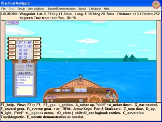
Compass Heading is in degrees True.
Boat Speed is in Knots. (0 to 20).
Boat distance Log records in Nautical Miles.
Your 3D World is a square area of 10 nautical miles in Moreton Bay Australia between Redcliffe and Moreton Island.
Explore this world by accelerating the Boat and Steering her using the Port and Starboard Controls.
The GPS is a fully fuctional unit which has all the functions of a real GPS. Accelerate the Boat and watch the GPS update your current Position showing Lat,Long,SMG,CMG. Add two Positions to act as Waypoints and then switch the GPS to Route function and see new information Cross Track Error as well as the Bearing and Range to the next Waypoint.
|